2 Stimmen (5.00 Durchschnitt) und 5.381 Ansichten  

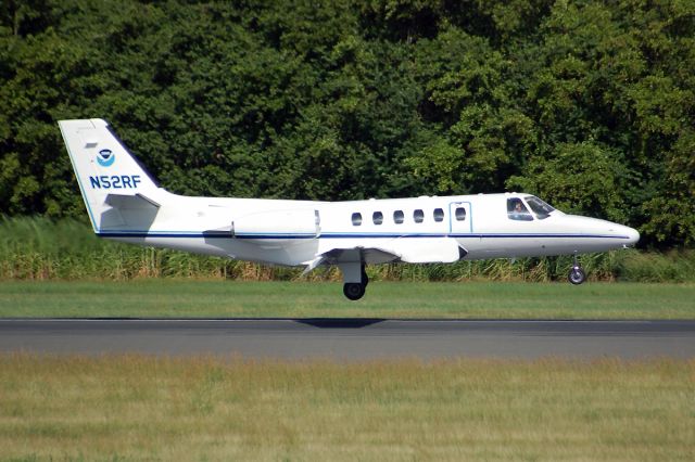
Cessna Citation II (NOAA52) - The Cessna Citation (CE-550) is a versatile twin-engine jet aircraft modified for acquiring remote sensing imagery. The aircraft is equipped with two equal sized camera ports which can support a wide variety of remote sensing configurations including large format aerial photography as well as data collection for digital cameras, hyperspectral, multispectral, and LIDAR systems.     Standard configuration includes space for two pilots, two equipment operators, and a scientific equipment rack. The aircraft can accommodate additional passengers depending on the amount of scientific equipment. The aircrafts unique side-by-side sensor port modification allows two different sensors to collect data simultaneously. The sensor ports have glass optical flats that allow the cabin to remain pressurized. Additionally, two high-precision GPS antennas provide signals to user receivers.     The Citation primarily supports the Remote Sensing Division of the National Geodetic Survey, collecting remote sensing data in support of coastal mapping and remote sensing research. Imagery acquired onboard the Citation is used for updating the shoreline and shore features on NOAAs nautical charts. The Citation also serves as an emergency responder during hurricane season by collecting digital photography of damaged areas caused by hurricane landfall.
/images/icons/csMagGlass.png mittel / groß / voll

Cessna Citation II (NOAA52)

Übermittelt

The Cessna Citation (CE-550) is a versatile twin-engine jet aircraft modified for acquiring remote sensing imagery. The aircraft is equipped with two equal sized camera ports which can support a wide variety of remote sensing configurations including large format aerial photography as well as data collection for digital cameras, hyperspectral, multispectral, and LIDAR systems. Standard configuration includes space for two pilots, two equipment operators, and a scientific equipment rack. The aircraft can accommodate additional passengers depending on the amount of scientific equipment. The aircraft's unique side-by-side sensor port modification allows two different sensors to collect data simultaneously. The sensor ports have glass optical flats that allow the cabin to remain pressurized. Additionally, two high-precision GPS antennas provide signals to user receivers. The Citation primarily supports the Remote Sensing Division of the National Geodetic Survey, collecting remote sensing data in support of coastal mapping and remote sensing research. Imagery acquired onboard the Citation is used for updating the shoreline and shore features on NOAA's nautical charts. The Citation also serves as an emergency responder during hurricane season by collecting digital photography of damaged areas caused by hurricane landfall.

Comments

Please log in or register to post a comment.

AKTIVITÄTENPROTOKOLL
Möchten Sie eine vollständige Historiensuche für NOAA52 bis ins Jahr 1998 zurück? Jetzt kaufen und innerhalb einer Stunde erhalten.
Datum Flugzeug Abflughafen Zielflughafen Abflug Ankunft Flugdauer
No Recent History Data
Basisnutzer (Die Registrierung als Basisnutzer ist kostenlos und ganz einfach!) haben Zugriff auf die Historie der zurückliegenden 3 months. Registrieren
 

Anmelden

Haben Sie kein Konto? Jetzt (kostenlos) registrieren für kundenspezifische Funktionen, Flugbenachrichtigungen und vieles mehr!
Wussten Sie schon, dass die Flugverfolgung auf FlightAware durch Werbung finanziert wird?
Sie können uns dabei helfen, FlightAware weiterhin kostenlos anzubieten, indem Sie Werbung auf FlightAware.com zulassen. Wir engagieren uns dafür, dass unsere Werbung auch in Zukunft zweckmäßig und unaufdringlich ist und Sie beim Surfen nicht stört. Das Erstellen einer Positivliste für Anzeigen auf FlightAware geht schnell und unkompliziert. Alternativ können Sie sich auch für eines unserer Premium-Benutzerkonten entscheiden..
Schließen